• Skip to primary navigation
  • Skip to main content
  • Skip to footer

Highlights:

  • Register Early for Tour Des Suds 2025!
Mountain Trails Foundation

Mountain Trails Foundation

We build, maintain and protect Park City, Utah's trails

  • About Us
    • History & MIssion
      • Vision & Values
      • Meet the Team
      • Trail Guidelines and Etiquette
      • Contact Us
  • Trails & Maps
    • Trails, Culture & Sustainability
      • Overview
      • Trail Guidelines and Etiquette
      • Transit to Trails Schedule
    • Summer Trails
      • Trails & Maps Overview
      • Summer Trail Areas
      • Parking Cams/Trailheads
      • Summer Trail Report
      • Interactive Map
    • Winter Trails
      • Winter Trails Overview
      • Winter Trail Areas
      • Winter Trail Report
      • Winter Parking/Trailhead Cams
      • Interactive Map & Conditions
  • News & Events
    • MTF News
      • Latest News
      • Sign Up for Newsletters
      • Sign Up for Text Alerts
      • Instagram
      • Facebook
    • Yearly Events & Races
      • Community Events & Races
      • Tour Des Suds
      • Triple Trail Challenge Series
      • Regional Trail Mixer
      • Live PC Give PC
    • Event Calendar
      • Visit our event calendar on ParkCityTrails.com by Mountain Trails
  • Donate & Volunteer
    • Support
      • Donations, Membership & Shop
      • Adopt A Trail
    • Get Involved
      • Volunteer
      • Ambassador Program

NEWS:

2021 Trail Maps Have Arrived

By Mountain Trails, Posted on July 9, 2021

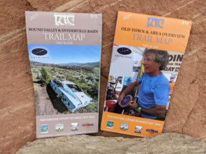
Our 2021 Trail Maps hit the shelves this week and are available both at local retailers and through our website. There are now two maps to cover our expansive trail network in greater detail.

The Old Town & Area Overview map provides a great perspective that includes everything from Bloods Lake Trail to Summit Park and great detail on Old Town Classics like Sweeney’s. This is the map you want if you’re exploring, Charlies 9k, the Wasatch Crest or Mid Mountain. 

Round Valley & Snyderville Basin is excellent for those who want to beat the heat and visit the Toll New World Trail starting at Weilenmann, or get a better view of the Olympic Park Trails. This map also shows our new Skyridge Trail above the Jordenelle and includes detailed inserts on the Trailside Bike Park.

Rick worked really hard on these and it shows! Hiking trails are better defined and the contrasting background makes it easy to read. Don’t think for too long about which one you need, get both, you’ll be glad you did.

ORDER MAPS

Footer

MOUNTAIN TRAILS FOUNDATION

MountainTrails.org
About Us

P.O. Box 754
Park City, UT 84060

Follow us

Text Alerts
Newsletters
Facebook
Instagram

External Links

Summit Land Conservancy
Basin Recreation District
Wasatch Trails Foundation
South Summit Trails Foundation
Summit County Animal Control
Utah Avalanche Center
Ski Utah
The Utah Nordic Alliance (TUNA)
Utah Open Lands

MTF Yearly Events

Tour Des Suds
Mountain Madness
LIVE PC GIVE PC


SPONSORS

SUMMIT COUNTY RESTAURANTS
INTERMOUNTAIN SPORTS MEDICINE - PARK CITY HOSPITAL
KUHL
EPIC PROMISE
SKULLCANDY

Copyright © 2025