SUGGESTED ROUTE BY PRIME CUTS
Mid Mountain Twist
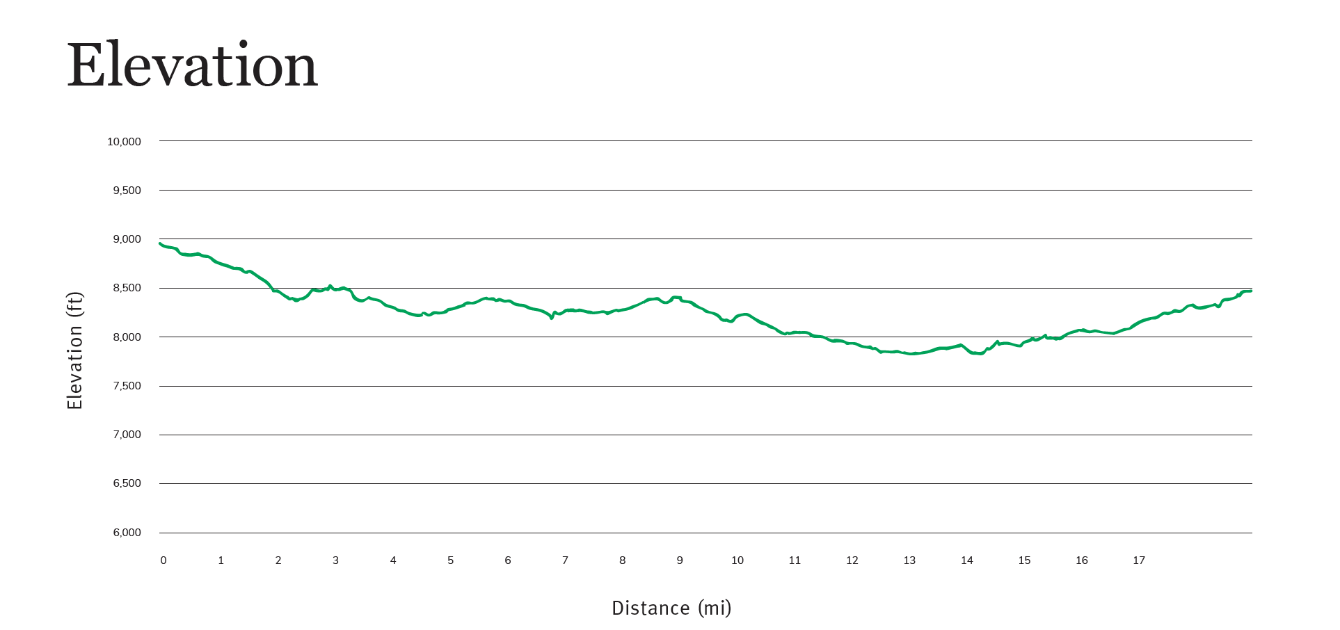
Mileage: 19+ | Elevation Gain: 2,590 ft 

Grunt Factor: 7 | Technical: 6
A new twist on a long but approachable ride. Expect manageable climbs, really fun descents, and just a couple of excellent tech bits reminiscent of Moab or Sedona. Plus, you decide how it ends!


Background
Mid Mountain is a 26 mile trail that traverses Park City’s two ski areas and hovers right around 8000 feet. It’s a classic bit of singletrack, and one that is hard to avoid when riding other trails. This trail offers such fantastic riding, views, connections, loop options, and more that the International Mountain Biking Association even designated it an Epic Ride—so this is not one to miss.
Description
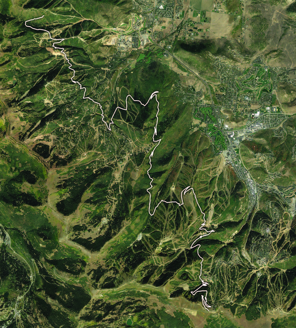
The classic “Whole Mid Mountain” ride starts at either Snowpark Lodge or Silverlake Lodge in Deer Valley. We thought we might offer a more challenging version by kicking off with a bit of extra fun at the top of Empire Pass, on the Corvair Trail. Right off the bat you’ll enjoy views of Guardsman Pass and the Bonanza Flats Conservation Area to the south, but as you turn your bike north and drop into Corvair, this ripping descent is the perfect warm up, with lots of lively rhythm, grippy corners, and speed. Alas, it’s only 1.5 miles long, but it might just be one of the best 1.5 miles of trail in Park City.
Next, you’ll head east on Mid Mountain and settle into the ride. For the ensuing 5.3 miles, you will pass some familiar trails from other rides in this book—Little Chief, Tommy Two Steps, Jenni’s, and more. The climbs never amount to more than a couple hundred feet of elevation gain at a time, and the grades are mellow. You’ll pass historic mining structures, cross through aspen and temperate forests, and pass under a number of chairlifts. At 5 miles into your ride, you will reach Crescent Ridge on Park City Mountain. This offers a fantastic vista of Park City and Snyderville Basin. Take a break here before gradually descending to the Spiro intersection.
At mile 6.7 you have a decision to make. This is the top of the Spiro trail, and it is the last bail out point before Holly’s—10 miles further down the trail. If you keep going, you will pass Armstrong trail, but that is an uphill only trail and riding down is not an option. The top of Spiro is a great spot to eat some food, check your water, and assess with your group whether you want to continue. Mid Mountain does get a bit more technical from here on out, and it can be a long haul if you’re caught in the middle of a warm summer day.
If you do press on, the next couple of miles are some of the most fun. After a 1.2 mile climb you will pass the bottom of the Pinecone Trail and a ripping cross-mountain descent begins. A fast bit with a couple big rock gardens and tight switchbacks puts you into a tricky traverse across the face of Iron Mountain. Stay in low gears here despite the speed because after the trail passes the top of Armstrong you can expect some technical rock maneuvers and short climbs that appear out of nowhere. You have a long way to ride still, and if you are fatigued, there is no shame in walking these bits. The trail will pass the entrance to Iron Man Trail and continue north. The trail will flatten out and cross the face of Iron Mountain before descending and wrapping around the north side of Iron Mountain.
The next stretch of Mid Mountain crosses The Colony gated community. At 2.9 miles in length, this section of trail will remind you of the first parts of the ride. The climbs are short but a bit more punchy, and you will be riding through some incredible aspen groves. You know you’re getting close when you see the “1 Mile to Red Pine Lodge” sign nailed to a tree. A couple more steep switchbacks, and you’ve made it the Red Pine Lodge and the top of the Red Pine Gondola.
At mile 15.5, the Red Pine Lodge is a sort of oasis. It’s a great spot to stop and fill up your water bottles or hydration pack, and there are tables and chairs to take a break from the saddle. But don’t sit down too long, or your legs will turn to cement. To the northwest, just past the gondola, Mid Mountain begins again. Taking the gondola down might be an option if it’s running, but if you press on it’s a short 1 mile to the top of the Holly’s Trail. At this point, you can descend towards the Canyons Village. Just 0.8 miles after passing Holly’s, you will ride out onto a service road. The service road to the left is steep but it connects you back to Mid Mountain. To your right is an expert-level DH trail called Red Coat. If you’re on a trail bike, Red Coat is manageable, but it will take a skilled rider to navigate the drops, roots, rock features, and jumps on a XC bike.
If you choose to continue on Mid Mountain when you exit the woods and come out onto a turn in a service road, head left and go up, up, up the road (your legs will feel this one) until you see a singletrack on your right. This is the continuation of Mid Mountain. Take the trail and keep on pedaling. 0.7 miles after starting up the road, you will pass the bottom of the Ridge Connector. Keep going on Mid Mountain for an enjoyable and high-speed descent on sidewalk-wide trail all the way to Ambush. Caution: this section of trail is wicked fast and stupid good fun, and there are a couple switchbacks that will come up in a giant hurry, so pay attention!
You will come to an open area of reddish dirt which is the top of Ambush and the start of Hunter’s Trail. The top of the Ambush Trail is where we stopped tracking the ride because as we said at the beginning, you get to decide how it ends.
Ambush connects to the lower section of Holly’s and Ricochet and goes down to the Canyons Village where there is ample food and drink. Or, you can connect to the Olympic Trail and ride clear to Kimball Junction for a beer at Maxwell’s or the Red Rock Brewing Co. Or you can go straight and ride Hunters Trail to the Pinebrook neighborhood. Any of these options offer excellent endings to this Epic. Riders looking for more mileage and climbing will love Hunters Trail, while those looking for a quick exit should head down Ambush and Holly’s. Expect any of these options to add 2–5 miles to your ride and may require a pickup from a friend or family member. Or, you can catch a free bus ride back to town.
Directions & Parking
This ride begins at the top of Empire Pass on State Route 224 (this part of 224 is also known as Marsac Avenue). Drive south on Marsac and climb up through Deer Valley toward the Montage Hotel and Empire Lodge. If you want, you can leave the car and start the ride here. This point is bus accessible as well. To reach the trailhead as we have written this ride, drive around the roundabout, passing the hotel and lodge, and continue up. After the first switchback a parking lot will be on your left and this is where Mid Mountain crosses the road coming from Silverlake Village. You could start the ride here as well by riding up Tour De Suds, but to reach the top, continue up the road for about 0.8 miles and at the top of the ridge, you’ll find parking on the right. This is where Corvair begins.
Route / Trail List
- Corvair (upper) – 0.4 miles
- Corvair Connector – 0.1 miles
- G. 1 – 0.2 miles
- Corvair (lower) – 8 miles
- Mid Mountain – 7 miles
- Options at the end – 2 to 5 miles
Crucial Trails Intersections
- Navigating Corvair – at 4 miles into Corvair you will round a right-hand switchback and encounter a fork. Take the trail to the left called Corvair Connector. Ride for 0.1 miles. The last bit of Corvair Connector includes a rock garden before T-boning into the T.G. 1 Trail. Go left here and continue for 0.2 miles where you will descend straight into the lower section of Corvair.
- Corvair, Mid Mountain Intersection – at mile 5 into the ride, Corvair runs into Mid Mountain. Head left (east) here and continue.
- Mid Mountain all the way – the bulk of this ride is on Mid Mountain until you reach Ambush where you can bail There is a sign at virtually every trail intersection with a helpful arrow pointing you in the direction you want to go. Stay on Mid Mountain to Ambush for 17.7 miles to complete this ride as we’ve described it.
