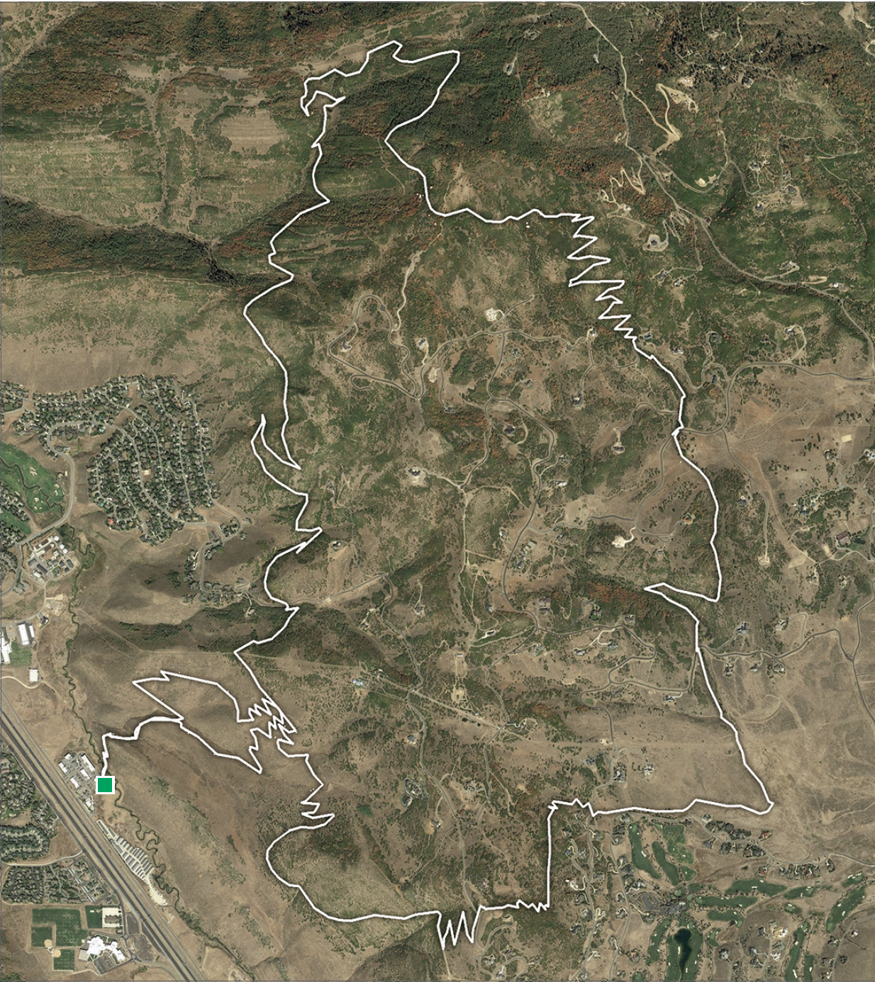
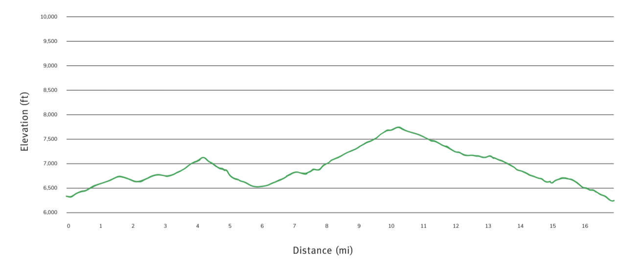
SUGGESTED ROUTE BY PRIME CUTS
The Real Flying Dog Loop
Mileage: 16.7 | Elevation Gain: 1501ft 

Grunt Factor: 7 | Technical: 6
A stout bit of climbing rewards you with a long, twisting, fun descent. But you have to earn it on the way up,with seemingly endless switchbacks through stunning high-alpine meadows, aspen forests, and scrub oak thickets.


Background
Like we noted before, Flying Dog is a classic Park City ride. We recommend riding this loop as early as possible due to its popularity, and weekdays are even better. As much as the descent is fun to ride down, a fair number of people like to climb it as well. So watch out for other trail users!
Description
The ride starts at the Bad Apple Trailhead, with a casual warm up on the Bad Apple and Fink Again trails for the first 1.5 miles. From here you will head southeast on the 24-7 Trail. After a quick descent, the climb starts again. 24-7 will pass three directional trails that are part of the Bob’s Basin network. Keep going on 24-7 for 1.5 miles until you hit Stealth. Take a left (east) on Stealth and continue pedaling up for another 0.5 miles. Towards the top, Stealth will widen quite a bit but keep riding until you see the beginning of the Glenwild Trail on your left.
Yup, keep on climbing. Just a few more switchbacks and 0.5 miles to the top where you will cross Fire Escape Road with some radio towers and a water tower to your right. This is a great spot to take a break and soak in the views of Park City and the Glenwild neighborhood.
Continue on and descend the Glenwild Trail down the eastside of the hill you just climbed. 1.7 miles of flowy singletrack,with some steep pitches and berms make this first descentan absolute riot. Unfortunately, it’s over a bit too soon as you descend quickly into the neighborhood. The Glenwild Trail continues east but at the end of the 1.7 mile descent the Cobblestone Trail begins on your left and heads north.
Cobblestone is a quiet 0.7 miles passing through meadows.Look for wildflowers here as you climb an easy grade toward the hills. After crossing Deer Hill Road, you start heading up the south end of Flying Dog. This is where the real climb begins.
The next 1.8 miles of climbing are strenuous. Lots of rocks,some steep pitches, and a high number of switchbacks make this climb feel like a chore. It’s also quite exposed to the sun,and on a hot day this short bit of trail can drain your energy quick. But, when it’s over, it’s over and you’re done with it.After passing the Preserve Connector Trail, there is about one last mile to the top where there is a nice bench to sit, rest, andrefuel for the descent.
This next part is why the locals love this trail. Descending the north side of Flying Dog is just plain fun. Catch it after a storm and the tacky dirt is well paired with the flowy turns through a dense aspen grove. On a dry day the trail speed is higher, and you can fly down—it might be a coincidence that the outline of the ride from an aerial view looks like a dog running with his ears flapping in the wind, but it feels like a pretty serendipitous coincidence. After about a mile, the descent mellows out but the rhythm never gives way. You’ll be pumping and pushing and pedaling all the way to the bottom. This little valley is gorgeous and Flying Dog is one of the prettiest rides in this book.
We would be remiss if we didn’t mention that you need to stay alert for riders and hikers coming uphill while you are bombing down. The closing speeds can reach 20 mph, and the trail is pretty narrow, so let it rip when you have long sight lines but please dial it back a bit on the blind corners.
Along the way, watch for two massive beaver dams, deer, and even moose in this area. The last part of Flying Dog loops back to the south and stays above the Jeremy Ranch neighborhood, passing the bottom of the Preserve Connector Trail and ending back on the north side of 24-7. Take the 24-7 Trail south back around the mountain for 1.5 miles. This bit of trail has some descending and a little climbing, but it brings you right back to the top of Fink Again.
Head just past Fink Again about 40 feet. The Crazy 8 Trail will be to your right. Crazy 8 is a 0.8 mile purpose-built descending trail with lots of rollers and berms. This is a fun trail and connects you right into the Bad Apple Trail and back to your car—not a bad way to end this Epic.
Directions & Parking
The Bad Apple Trailhead is your beginning and end for this ride, and you will need a car to reach it. From Park City, headout of town on S.R. 224 toward Kimball Junction. Cross over I-80 and turn left on Rasmussen Road. Follow the road for a couple of miles where a business center will be on your right.
Street Address:
2740 Rasmussen Rd
Park City, UT 84098
Route / Trail List
- Bad Apple – 0.5 miles
- Fink Again – 1 mile
- 24-7 – 1.5 miles
- Stealth – 0.5 miles
- Glenwild – 2.2 miles
- Cobblestone – 1.7 miles
- Flying Dog – 6 miles
- 24-7 – 1.5 miles
- Crazy 8 – 0.8 miles
- Bad Apple – 0.5 miles
Crucial Trails Intersections
- Bad Apple to Fink Again – Bad Apple is just 0.5 miles long before you come to a trail intersection. Stay left to pick up Fink Again as the trails to your right are the bottom of directional downhill trails.
- Fink Again to Stealth – at mile 3, turn left (east) and head up Stealth.
- Stealth to Glenwild – Stealth is only 0.5 miles long and the end of it is on a wide dirt and gravel mixed surface path. The Glenwild trail will be on your left near the top of this path.
- Cobblestone to Flying Dog – Cobblestone is a mellow grade trail passing through a meadow in a private neighborhood. The trail will cross Deer Hill Road twice. After the second crossing, Flying Dog begins.
- Flying Dog all the way – on this ride, Fly Dog passes the top and then bottom of the Preserve Connector Trail. Be sure to follow the signs and continue on Flying Dog to complete the ride.
- Flying Dog to 24-7 – at mile 13.5 in the ride, Flying Dog will T-bone into 24-7. Head left (south) here to continue. After 0.2 miles you will encounter the 24-7 Access Trail for the Jeremy Ranch neighborhood. Go past this junction and continue southeast on 24-7.
- 24-7 to Crazy 8 – at mile 15.1, 24-7 is joined by Fink Again from the right (west). About 40 feet past this trail junction, Crazy 8 begins on your right.
- Crazy 8 to Bad Apple – Crazy 8 is one of four descending only DH trails in the Bob’s Basin trail network. All of the trails join Drop Out toward the bottom which links directly into the top of Bad Apple where you can ride out to your car.
