Rebecca Marriott Champion, long-time resident and local hiker, donated to MTF to meet the match requirement for Seldom Seen grant funding. In building Seldom Seen for downhill bike traffic, we create a hike-friendly zone including Silver Spur, Armstrong, Dawn’s and Lower Spiro trails. Many thanks to Rebecca for having a vision for this hike-friendly route and for putting a winning donation where her feet go!
Bike Swap April 29-30, 2023

The 2023 bike swap has been announced and its new beneficiaries, the Park City High School Mountain Bike Team, are eager to have you participate. It’s a great opportunity to sell an old bike or equipment or buy new gear.
Don’t forget that if you want to sell anything it must be dropped off prior to the swap. Here are the details form PCHSMTB :
WHEN: Saturday, April 29, 8am-5pm and Sunday, April 30, 11am-3pm
WHERE: Utah Film Studios: 4001 Kearns Blvd. Park City, Utah (across from Quinn’s junction)
25 Years of Mapping Park City Trails
Long before cell phones, Google Earth and apps like Trailforks and AllTrails, topographic paper maps were the tool of choice for navigating trail systems. Contour lines conveyed grade, elevation gain and loss, while serpentine, multi-colored, green, blue and black lines, represented new adventures of varying difficulty in the form of singletrack trails. In those days, it was understood that getting “lost” was a distinct possibility and sometimes welcomed.
Mountain Trails has been involved in the production of the Park City trail map since the original went to print in 1998. Thanks to Dawn Bowling, (our beloved resource manager, who we lost to cancer in 2013), for being a packrat of best kind, and hanging onto at least one copy of each map over the years. Now, carefully stored in a plastic tote labeled “Map Library”, they represent a physical, historical timeline of the growth and evolution of our trail system, from a handful of hand-built pirate trails, mine roads and mine grades, to the 500 mile, world-class, IMBA Gold Level trail system we have today.
The original, “1998 Hiking & Biking Trail Map”, as it was titled, is a small and simple, yet purposeful production. On the front you’ll find what looks to be a hand-drawn overview map showing a hodgepodge of mine roads and just a few dozen trails, including Park City hand-built classics like Gravedigger, Sweeny’s Switchbacks, the original Tour Des Suds (pre-Empire Pass), TG1 & 2, along with a lone Round Valley trail labeled; “Round Valley”. You’ll also discover some long-forgotten gems like Jurassic, Bed Springs and my favorite, a trail named “Game Trail”. On the back side are several color-coded elevation profiles and descriptions of various routes throughout the area. This was a true adventure map, with no trail mileage or difficulty ratings and no topos to discern grade or elevation gain and loss. Your only reference points were one of the many artist renderings- historical and non-historical landmarks including various mine buildings, the ”Old Car” in Round Valley, the “Water Tank” in Daly Canyon, along with the “Blue Dumpster” and “Junk Yard”.
Two years later, at the turn of the century, our trail system was beginning to blossom. The 2000 trail map mirrors this expansion, with miles of “purpose-built” trails like the newly completed- Spiro at Park City Mountain Resort, Lost Prospector high above the Rail Trail and Deer Valley Drive, and Rambler, Kari’s & High Side in Round Valley. Also represented was an extensive lift-served system at Deer Valley with 45+ miles of trail along with sections of the Mid Mountain Trail, some complete and others still labeled “under construction”.
Mountain Land Association of Governments or MAG, GIS coordinator, Andrew Woolly would produce those first few early cartographic efforts, before Trish Murphy Cone, also with MAG, would take the reins in 2003, beginning a 16-year run as designer/cartographer. There would be literally hundreds of miles of trail and thousands of acres of protected Open Space added to the map during that time. Trish did a phenomenal job documenting that growth and understood the need for a detailed and accurate map. Her passion for trails, wildlife, the open spaces that supported them and local history were obvious and always on display. Her attention to detail and personal touches contributed in a big way to the map’s character and long-running success.
I would literally have to write a novel to describe all the changes/additions that took place with the map over the next two decades, but here are a few of the major highlights to give you a sense of what was taking place:
2005- includes the iconic Mid Mountain Trail in its entirety, a well-developed system in the Glenwild area, north of I-80, that included the Stealth trail, Cobblestone, 24-7 along with some early downhill, bike-only trails in the new, Bob’s Basin. Rob’s, Collin’s & Ambush are complete, the Swaner Nature Preserve is highlighted, and several sponsored trail loops are identified, including the Glenwild Loop, Lost Prospector loop, the High Alpine Loop and the Town loop.
2007- Flying Dog is complete at Glenwild along with new trail offerings at the Utah Olympic Park, including ???? conservation efforts were well under way and protected easements that enabled trail development would be highlighted and shown in the legend as “Protected Open Space”.
2009- the Old Town window of the map would be flipped to a “bottom up”, users’ perspective, in an effort to better represent the nearly 3,000 feet of vertical relief from Main Street to the Wasatch Crest.
2011- the now vast system would be broken down into six distinct, color-coded, trail area “windows”. The map would also mirror wayfinding signage on the ground with newly added “Location Markers” in Round Valley, Glenwild, the Mid Mountain Trail and the Wasatch Crest.
2012/13- Park City’s recent designation as “The World’s First IMBA Gold Level Ride Center” would be acknowledged on the cover along with new trail additions, Armstrong, Jenni’s and Pinecone Ridge
2014- future ED, Lora Smith, would grace the cover, and the first “MTF Crew” photo would be added under the legend, the start of a new tradition
2017- MTF 25th anniversary map with many historical trail photos and acknowledgment of individuals who played a role in creating the PC trail system. Freemason is new.
2020- Bonanza Flat first appears on the map and includes the Blood’s Lake trail
2021- with the continued expansion of our trail system into areas like Clark Ranch, Skyridge and Bonanza Flat, we transition into a 2-map, format. Charlie’s 9K is complete along with the Lake Lackawaxen trail.
2022- weather and tear-resistant paper is used for the first time, improving the durability of the map
The map covers have always been an integral piece of the MTF map production. They represent different trails users, uses and experiences as well as our local trail culture. And what better way to show off our trails! Over the years the covers would also acknowledge and memorialize individuals who played a major role in the trajectory of our organization and trails in general, including previous Executive Directors, Carol Potter and Charlie Sturgis and Basin Rec trails planner, Senta Beyers. One year, we even did a cover of our trail crew on the Pulp Friction work site. More recently, in an effort to maintain that organic, home-grown feel for the map, we have held a yearly cover-photo contest. The map “panels” would be used to promote our long-running summer trail running series, trail etiquette and to recognize a quickly growing list of Adopt-A-Trail sponsors. We have packed a lot into those 27×36” pieces of paper.
In 2019, Trish would retire from the “little” map production she helped create, and in 2020, with big shoes to fill, we would welcome cartographer, Jay Hill, to the team. Jay brought with him 14 years of GIS experience working for the Utah Geological Survey branch of the DNR. With a fresh set of eyes and a passion for mapping and mountain biking, Jay would tap into the latest technology to visually enhance the map, along with a renewed focus on emphasizing the trails, themselves.
For 2023, we’ll have new trail additions including Mother Urban, Cyn City, Sparky, Change Reaction and Ripple at Deer Valley. The accuracy of our trail files will be improved, and the background and trail colors will be enhanced to improve the overall look of the map.
While the demand for paper maps may not be what it once was, they remain a viable tool for those of us who prefer a physical, hands-on, reference. You’ll still find the MTF map in bike shops, at the Chamber, on garage and office walls, and in backpacks. Like our trail system, the map has always been a work in progress. Looking through these maps in detail over the past week has been an eye-opening reminder of how much effort has gone into their creation, and that of our trail system. As the saying goes, “It takes a village”, and there have been many villagers involved in this ongoing legacy. We owe them all a great debt of gratitude.
Trail Hero – Todd Henneman
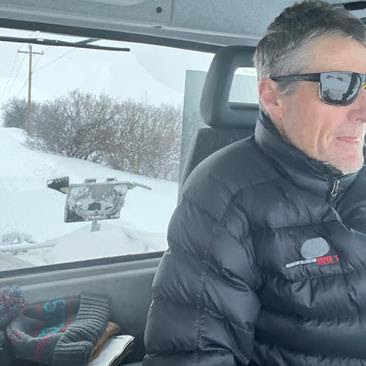
Shout out to Todd Henneman for stepping up and taking on Pantera Roja. She’s a feisty cat and doesn’t take easily to new groomers. But Todd has got her tamed and will be cat-siting while the MTF crew is in Reno at the International Trails Summit in mid-April.
A little bit about Todd: first, it’s hard to find a picture of him without Susie and/or ski goggles – a testament to his character. Many of you know him, but if you don’t, I’ll just say, too bad for you. You know that super chill dude who everybody loves? The one who exudes cool in a quiet, understated, but all-knowing way, and never talks about himself, despite a lifetime of outdoor accomplishments. Yeah, Todd’s that guy. And he’ll probably dislike that I am calling out his awesomeness, but hey, I’ve decided today is a day to rankle a boss. . . which Todd is to me as he also sits on the Board of Directors at MTF where he has been an enormous help with strategy and morale. Todd, THANK YOU!
Mountain Trails Thanks The Goldfields
Thanks to the Goldfield Family for understanding what it means to have a good home. Their contribution helped MTF pay the final invoice on building out the new HQ. Can’t say enough about the generosity of this family. Thank you, Goldfields!
February Trail Report
The Greatest (and deepest) Snow on Earth ™
You’ll rarely hear Parkites complain about a big winter and countless, deep, powder days (unless you live in Summit Park and don’t own a snowblower). We all “moved here for the winters and stayed for the summers,” after all. And when four Utah ski resorts are reporting the most snowfall in North America, in January, you know that it’s a winter of epic proportions. But is it possible to have too much of a good thing???
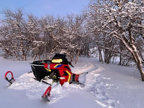
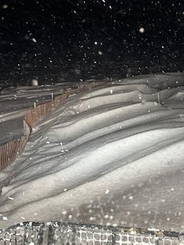
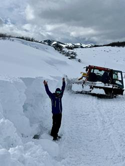
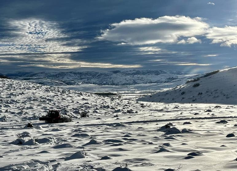
As the first sustained period of high pressure since November settles in upon the Wasatch Back, those of us that work in the snow business are finally getting a little reprieve and a chance to catch our collective breathes. For the hearty individuals who work out in it – the snowplow operators, groomers, lift-mechanics, ski patrollers and the under-appreciated lifties, a winter like this can be extremely challenging. But it’s a challenge that we all embrace, despite shovel-weary arms and tired ski-legs.
The MTF Winter Crew has had its own set of snow-related challenges this winter. The snow gods, Urll and Boreas, chest-bumped and threw down a relentless sage-and-singletrack swallowing snowpack on the Round Valley trails, unlike anything I’ve seen since we started the grooming program 16 years ago. And nearly all these storms have been accompanied by strong winds that have created dense, waist-to-head-high, wave-like drifting conditions that are hard on both the equipment and the operators.
Burying a snowmobile multiple times in three-plus feet of snow can be a backbreaking, sweat-inducing, shovel-fest. And leveling drifts with the cat often requires multiple passes and several hours behind the wheel. Our two grooming snowmobiles and the tracked 4-wheeler have all been out of commission at some point this winter. And la Pantera Roja (our cat) has also been temporarily sidelined with mechanical issues, twice.
Prior to the start of this epic season, our soon-to-be rookie groomers were questioning, why place so many PVC and fiberglass markers out on the trails, late fall? Well, grasshoppers, it’s for rare years like this when one might actually lose the trail. And THIS winter, trails have literally been lost, multiple times. Grooming singletrack is a challenging enough endeavor, but in a year like this, the real challenge has been FINDING the singletrack, and in some cases, even the Nordic.
Remember the Etch-A-Sketch you played with as a kid? Shake it up, your artwork disappears, and you have a blank slate. That pretty much sums up the snow/wind effect on the singletrack this winter. Immediately after a storm passes, we typically do multiple packing laps with the snowmobile, and then a few more with the snowmobile/drag combo. More often than not this year, our efforts have been obliterated, as storm after storm wipes the slate clean.
Because of this year’s non-stop snow-train, part of our daily work plan has included post-storm snowshoeing or skinning the trails (along with a little help from our friends) armed with the TrailForks gps app, to make sure we’re actually “on-trail”. Kinda like leaving breadcrumbs for the snowmobile to follow. All in the name of winter recreation.
So, the next time you’re grinning ear to ear after multiple, bottomless resort laps, a fast and firm fat bike ride, or a skate on perfectly groomed corduroy, be sure to thank those winter warriors who work tirelessly to make it all happen. And DON’T forget the lifties.
Enjoy these bluebird days and soak up some of that rare vitamin D, because February is typically one of the snowiest months of the year…
Have a great one out there!